Make shapes in a filled map?

The Student

New Member
Joined
Sep 27, 2018
Messages
24
Office Version
  1. 365
Platform
  1. Windows
Hi. Hope someone can tell if this is possible in Power BI.

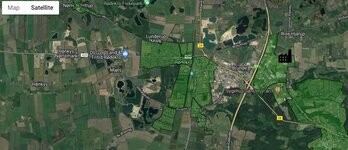
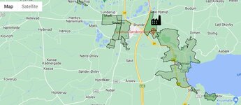
I like to make a map as illustrated (see attached picture) - either as a map or satellite.
It´s important that I can see where the green shapes is located (city/roads)

Is it possible to make shapes like this in Power BI?

I thought about Shapes maps in Power BI, but as I understand you won´t get the geographical location.
 

Attachments

  • map.JPG
    map.JPG
    112.3 KB · Views: 7
  • map2.JPG
    map2.JPG
    69.1 KB · Views: 6

Excel Facts

Create a Pivot Table on a Map
If your data has zip codes, postal codes, or city names, select the data and use Insert, 3D Map. (Found to right of chart icons).

Forum statistics

Threads
1,224,820
Messages
6,181,157
Members
453,021
Latest member
Justyna P

We've detected that you are using an adblocker.

We have a great community of people providing Excel help here, but the hosting costs are enormous. You can help keep this site running by allowing ads on MrExcel.com.
Allow Ads at MrExcel

Which adblocker are you using?

Disable AdBlock

Follow these easy steps to disable AdBlock

1)Click on the icon in the browser’s toolbar.
2)Click on the icon in the browser’s toolbar.
2)Click on the "Pause on this site" option.
Go back

Disable AdBlock Plus

Follow these easy steps to disable AdBlock Plus

1)Click on the icon in the browser’s toolbar.
2)Click on the toggle to disable it for "mrexcel.com".
Go back

Disable uBlock Origin

Follow these easy steps to disable uBlock Origin

1)Click on the icon in the browser’s toolbar.
2)Click on the "Power" button.
3)Click on the "Refresh" button.
Go back

Disable uBlock

Follow these easy steps to disable uBlock

1)Click on the icon in the browser’s toolbar.
2)Click on the "Power" button.
3)Click on the "Refresh" button.
Go back
Back
Top