monkeyharris
Active Member
- Joined
- Jan 20, 2008
- Messages
- 372
- Office Version
- 365
- Platform
- Windows
Dear all,
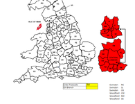
I have a postcode map that shows UK postcodes inside each zone and a corresponding list.
There is a search field where the user enters the postcode and what i want is for the corresponding map square to change colour for easy and quick reference to where it is.
Under this i know how to make a field show which branch is closest to the chosen postcode, i'm just struggling with how to make the image change colour. I couldn't copy the map into a mini sheet so attached an image.
| IDS Postcode Map.xlsx | ||||||||
|---|---|---|---|---|---|---|---|---|
| T | U | V | W | X | Y | |||
| 56 | ||||||||
| 57 | Enter Postcode | RH | Swindon | RG | ||||
| 58 | IDS Branch | Swindon | SL | |||||
| 59 | Swindon | OX | ||||||
| 60 | Woodford | CM | ||||||
| 61 | Woodford | RM | ||||||
| 62 | Woodford | SG | ||||||
General Tariff | ||||||||


